YOUR GUIDE TO PAS128
WHAT IS PAS128?
British Standards Institution PAS 128, Specification for underground utility detection, verification and location is the publicly available specification document which allows the utility survey industry to deliver its services to a recognised level of accuracy. Although it is aimed at the survey practitioner, we understand that our clients need to know how to specify a PAS128 survey.
This website is independent to the material from the British Standards Industry (BSI) and the Institution of Civil Engineering (ICE). This information is designed to explain how to understand and use the PAS128 specification in your future tender documents for surveys associated with underground utility infrastructure.
GPR Surveys VS PAS128 Standards
Ground Penetrating Radar (GPR) Surveys are often mistaken for Underground Utility Surveys to PAS128 Standards. GPR has a number of uses beyond just detecting underground services and can be utilised in a vast number of environments. GPR is still a tool used to help us complete a survey to PAS128 Standards, however we have written a quick guide to show you the extra benefits a GPR Survey can bring, just click on the button below.
PAS128 – The robust specification for underground utility detection, verification and location.
PAS128 provides a robust methodology for delivering utility surveys in the UK. It focuses on levels of accuracy – referred to as Survey Category Types – that you can specify when requiring a PAS128 compliant underground utility survey.
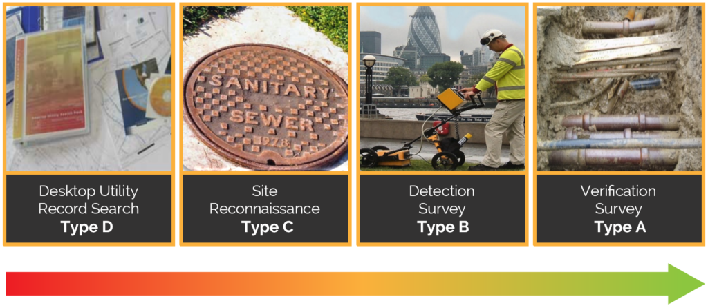
There are four Survey Category Types ranging from D – A. Ordinarily we would follow these Survey Types in order to get your desired outcome. For example, if you would like a Type B survey, we would recommend we conduct a Type D and C before commencing a Type B.
What type of Survey do I need?
It is important that you have an understanding of what type of survey you want and what will be the likely outcome of a completed survey. Our team here at Malcolm Hughes are happy to have an open dialog so that particular survey methodologies can be discussed and proposed project parameters can be agreed upon. The below shows what each Survey Type entails and how we use and deliver this information. Below this section are tables showing these quality levels (QLD/C/B/A) and we recommend you keep this page bookmarked to help reference these for when you order a survey.
TYPE D – Desktop utility record search
TYPE C – Site reconnaissance
TYPE B – Detection
TYPE A – Verification
Post survey meeting
Post survey, a discussion and/or meeting takes place so that the Survey Manager can explain to the client the accuracies achieved and any limiting factors. At this point it may be appropriate to suggest other methods of survey to achieve greater levels of accuracy in areas of concern/strategic project importance.
How accurate is my Survey?
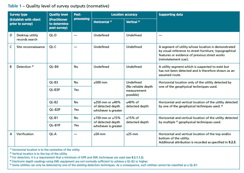
Quality Levels (QL) set out the accuracy to which the survey data is captured for specific purposes, the quality expected of that data and a means by which to assess and indicate the confidence that can be placed in that data.
A PAS 128 compliant utility survey will consist of many underground utilities and it is possible that all of the above Survey Types will be featured in some way. A particular single utility may have several QL designations along its route depending on whether it has been exposed (verified), successfully detected using one or multiple geophysical techniques or identified from records only at a particular section along its length.
The below table shows the quality level outputs for each survey type. We will always endeavour to give the highest quality level possible based on your requirements but depending on environment this may not always be possible. If you are unsure, please do not hesitate to reach out to your Survey Manager.
Type B Surveys in more depth
As a company, although we specialise in all types of surveys from D-A, our main speciality lies within Type B Detection. We have a large host of equipment at our disposal however our most common are:
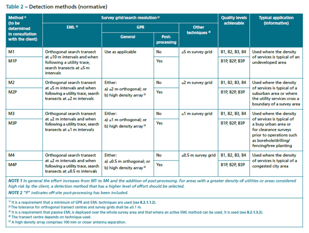
The table below shows “Detection Methods,” and is taken from the PAS128:2022 specifications, although this is not to be confused with the equipment we use. To help understand the table below, it is easier to term the “M”s as defining the measurement interval in which we look for and detect services, rather than detection methods. This ranges from M1 – M4 and will help us when you specify your survey and how often you would like your utilities plotted. The intervals in which we conduct surveys can make a significant difference to cost, so please make sure you speak to your Survey Manager to find out how we can tailor our methods to keep your survey cost efficient. We suggest you keep the table below to hand so that you are able to reference it when asking to quote for your survey.
Limitations with PAS128 Utility Surveys
Unfortunately the location of underground utilities in most circumstances cannot be 100% guaranteed using Types D, C and B due to the lack of visual verification. Depending on the given accuracies they are however very dependable for health & safety and/or design implications and should be the first point of call before undertaking intrusive works. PAS128:2022 was primarily designed for health & safety and to help avoid accidents at work. Listed below are some of the limitations that may affect the results of a utility survey:
Want more information?
If you would like more information on Underground Utility Mapping to PAS128 Standards or would like to go through any of the above, please see our CPD page where you are able to book a 1 hour presentation with us, free of charge, to explain in more depth and show real life examples of how this Standard is put into place.


